
Manhattan Beach
Manhattan Beach · Los Angeles County · California

Did you dive today?Please share the visibility to make our algorithm more accurate.
Report visibilityToday's forecast
Updated 10:00 AM PT today · July 28, 2026Dawn is the clearest window — onshore wind picks up by late morning and surface chop stirs the bottom through the afternoon.
7-Day Forecast
Map · getting there
33.884° N · 118.413° W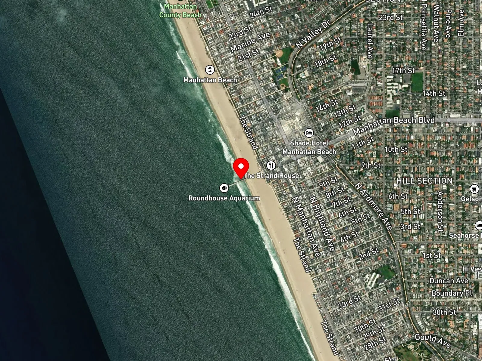
Manhattan Beach, CA 90266
About Manhattan Beach
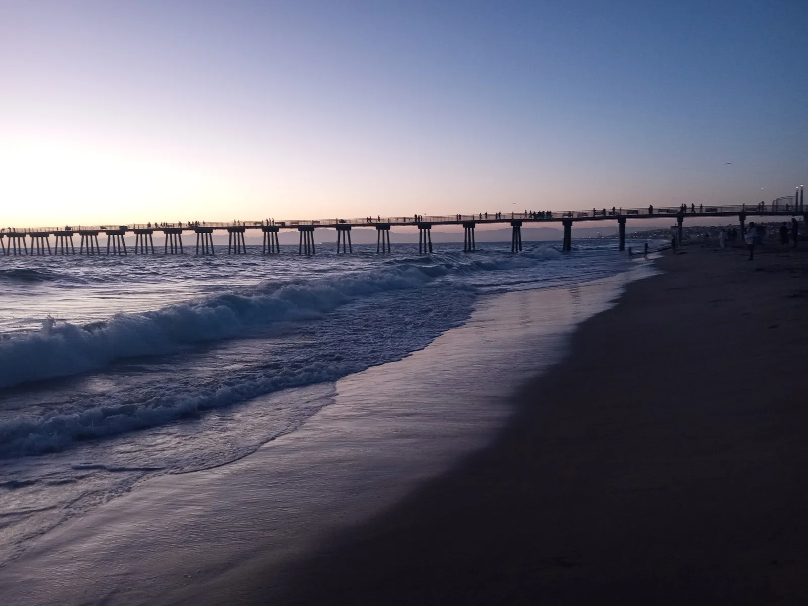
Manhattan Beach is a sand-bottom municipal beach in the South Bay of Los Angeles County, anchored by Manhattan Beach Pier at the foot of Manhattan Beach Boulevard. The pier is a 928-foot concrete structure built in 1920 to replace an earlier 1912 wooden pier. At its seaward end stands an octagonal Mediterranean-style building that houses the Roundhouse Marine Studies Lab and Aquarium, operated by the Roundhouse Aquarium Teaching Center. A concrete artificial reef sits in the water about 65 feet past the end of the pier and serves as a pier-fishing target; it cannot be reached from shore. Behind the beach runs the Strand, a paved pedestrian and bicycle path that traces the full length of Manhattan Beach and continues south through Hermosa Beach into Redondo Beach as the South Bay Bicycle Trail. The northernmost segment of the beach, between 38th and 45th streets, is known as El Porto and sits next to the Hyperion Treatment Plant and the Chevron facility. The substrate at El Porto is rockier than the fine sand along the rest of the shoreline.
The bottom is sand throughout the named beach, with breaking surf and no shore-accessible rocky reef or kelp. The rockier substrate at El Porto is a small local variation and does not amount to a reef structure, and the artificial reef at the pier end is reachable only by hook-and-line from the pier deck. The spot is a surf zone biome.
Surfing is the dominant in-water activity, with El Porto the most well-known break at the north end. Beach volleyball is also prominent. The courts immediately south of the pier host the AVP Manhattan Beach Open, the most prestigious tournament in domestic beach volleyball. Hook-and-line fishing from the pier is common and targets the artificial reef offshore. Swimming runs the full length of the beach in summer. With no rocky structure or kelp to hold fish, spearfishing, snorkeling, and scuba from shore are all uncommon.
Paid municipal lots sit at the foot of Manhattan Beach Boulevard and along the Strand-adjacent blocks at hourly rates during the day, with metered street parking on Highland Avenue and a separate paid lot at El Porto at the north end. Spaces fill before 10 a.m. on summer weekends. Spearfishing is prohibited within 1,000 feet of Manhattan Beach Pier per California Code of Regulations Title 14 Section 1.88. Outside that exclusion, fishing and spearfishing are legal under standard California regulations.

Surf Zone
The surf zone biome consists of sandy beaches and breaking waves. The action of surf disturbing the sand and kicking it up exposes marine invertebrates, buried in their shallow dens. This natural exposure of invertebrates attracts all kinds of fish, looking for an easy meal. Learn more about this biome and the species found in it by clicking the link below.
Learn more in the Biome GlossaryTarget Fish Species
Nearby beaches

Gain the Power
of the Oracle.
Ocean Oracle sees the future. Get 7-day visibility forecasts for every beach, plus alerts the night before clarity peaks — so you never miss a prime day.
Free shows you what the ocean looks like today. Ocean Oracle shows you the week ahead and the fish waiting for you down there.
Visibility predictions for the entire week ahead at any beach. Plan dives, schedule charters, book trips — without guessing.
The night before any beach hits prime conditions, Ocean Oracle pings your phone. Wake up knowing exactly where to go.
Track your favorite beaches in one place. Forecasts and alerts for everywhere you dive.
For every beach: what species are there, when they show up, and how to target them. Built by spearos, for spearos.
See the future. Dive on the right days.