

Warm Water Rising: California Declares an Emergency as a Potentially Record El Niño Takes Hold
Governor Gavin Newsom's September 21 proclamation mobilizes state resources as NOAA gives the developing event better than a 90 percent chance of turning very strong, and a pulse of warm ocean water due on the California coast by October is expected to lift sea level by roughly a foot.
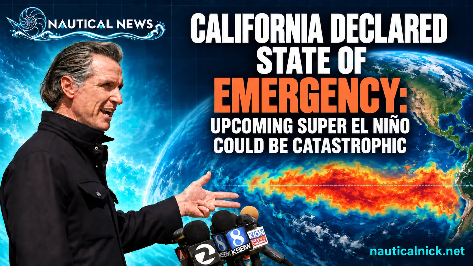
On the morning of Monday, September 21, the first storm of the season was still nowhere on the map. Off the coast, a slow-moving pulse of warm water that has been crossing the Pacific since summer was closing in, expected to push California sea level up by roughly a foot by October. In Sacramento, the governor was signing an order that treats the coming season as an emergency before it has begun.
Governor Gavin Newsom's proclamation, issued the same morning, activates the California Office of Emergency Services and directs state agencies to pre-position flood equipment, prepare the California National Guard for flood response and search-and-rescue missions, and fast-track environmental permits, according to a release from the Governor's Office. The trigger is a developing El Niño that NOAA's Climate Prediction Center now gives better than a 90 percent chance of reaching very strong intensity this fall and winter, with a 75 percent chance of exceeding a threshold no event has crossed since the modern record began in 1950. A coastal-trapped Kelvin wave, a slow-moving mass of warmer, higher water that forms when El Niño weakens the equatorial trade winds and then propagates north along the eastern Pacific shelf, has been tracked by satellite past Acapulco in mid-June, Puerto Vallarta in mid-July, and the tip of Baja in early August, and is expected at San Diego in late September or early October, Los Angeles 2 to 3 days later, and San Francisco by mid to late October, according to the Sacramento Bee and the Los Angeles Times.
The proclamation
The order cites "conditions of extreme peril to the safety of persons and property... due to the developing El Niño event," according to the signed proclamation. It directs Cal OES to coordinate statewide preparation for "severe weather, flooding, coastal flooding, erosion, mud and debris flows, and related impacts," including atmospheric rivers, and it notes that the state "has already begun to experience effects attributed to this El Niño event, including unusual precipitation and significant coastal flooding." The proclamation cites an August 13 Climate Prediction Center report that put the odds of a historic-strength event at 69 percent; the center raised that figure to 75 percent on September 10. It does not order evacuations, close beaches, or impose any restriction on the public. Its function is to move money, staff, and equipment ahead of the storms rather than react to them.
Cal OES Director Caroline Thomas Jacobs said the agency is "leading California's statewide efforts by bringing state and local partners together, conducting advance planning efforts, and identifying potential needs before impacts occur," according to KTLA. Under the order, Caltrans is pre-positioning traffic control and snow-removal equipment on high-risk highways, the state is staging sandbags and pumps, and multilingual preparedness communications are being expanded, per the Governor's Office release. Weather.com noted that this is not the first El Niño emergency declaration in California, but it may be the first made this early.
How strong the ocean is running
NOAA's most recent El Niño diagnostic discussion, dated September 10, put the Niño-3.4 region, a stretch of the central-equatorial Pacific whose sea surface temperature anomaly defines El Niño strength, at 1.8 degrees Celsius (3.2 degrees Fahrenheit) above the long-term average as of August. The Climate Prediction Center forecast gives the event a greater than 90 percent probability of reaching very strong intensity through the Northern Hemisphere fall and winter, and a 75 percent chance the three-month Relative Oceanic Niño Index, a version of the sea surface anomaly adjusted for the warming background, exceeds 2.5 degrees Celsius. No El Niño has cleared that mark since the modern record started in 1950, according to the discussion.
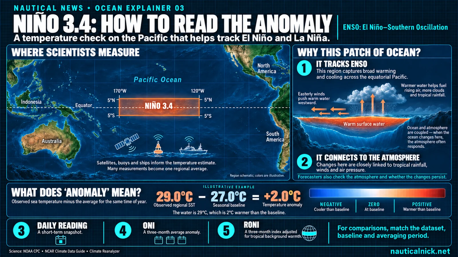 Niño 3.4 is the patch of the equatorial Pacific between 170 and 120 degrees west whose temperature departure from normal defines El Niño strength. The 29 minus 27 example is illustrative, not the current reading. Nautical News explainer.
Fox Weather reported that the Climate Prediction Center now puts the odds of the event becoming the strongest since 1950 at 75 percent. EarthSky cited climate scientist Daniel Swain estimating a comparable 70 percent likelihood, and quoted Swain saying the event "will likely contribute to significant regional drought and flood events, as well as extreme heat" on top of the long-term warming baseline. The Climate Prediction Center expects the event to keep strengthening through the end of the year.
The animals got here first
The ocean announced this El Niño months before the governor did. Since spring, Southern California has logged a whale shark off Malibu, hammerheads filmed 3 times between Santa Barbara County and Laguna Beach, killer whales from a warm-water population off San Diego, and devil rays from Catalina to the Nine Mile Bank. September added a 648-pound blue marlin landed off San Diego on September 14, which the landing that weighed it labeled the "El Niño fish," and striped marlin free-jumping off Newport Beach so often that one photographer told For The Win she could not recall a year she had seen them locally almost every day. Around Catalina Island, where sea turtle sightings have climbed steadily over the past decade, green, olive ridley, and loggerhead turtles are all on the list, according to the Catalina Island Marine Institute.
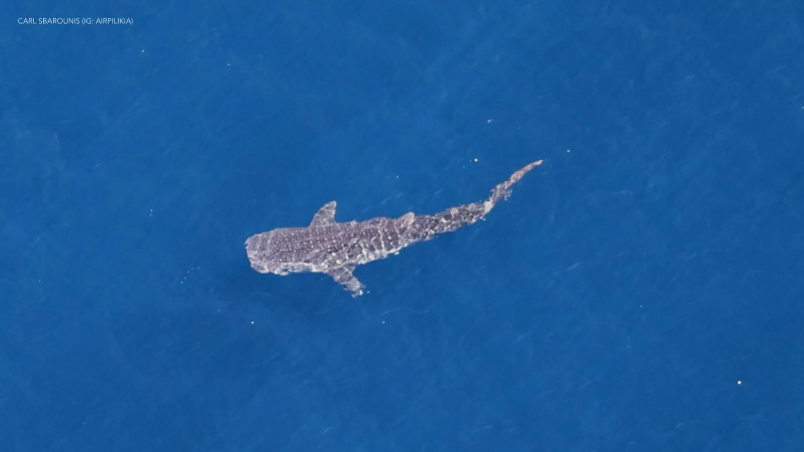 The whale shark filmed between Santa Barbara Island and Malibu on September 9, 2026. Photo: Carl Sbarounis (Instagram: airpilikia).
Then came the one that made national news. On September 16, Huntington Beach lifeguards found an olive ridley sea turtle digging a nest and laying eggs near Seal Beach, and on September 19 a turtle, possibly the same female, nested again just south of the Huntington Beach Pier. NOAA Fisheries called it the first documented olive ridley nest on the West Coast, and the Los Angeles Times reported it as the first known instance of a sea turtle of any species spontaneously nesting on the U.S. West Coast. Each nest holds an estimated 50 to 100 eggs, fenced and monitored through an incubation of 45 to 60 days. The full accounting of what warm water has brought this coast, species by species, with who saw what and when, is in The El Niño Arrivals.
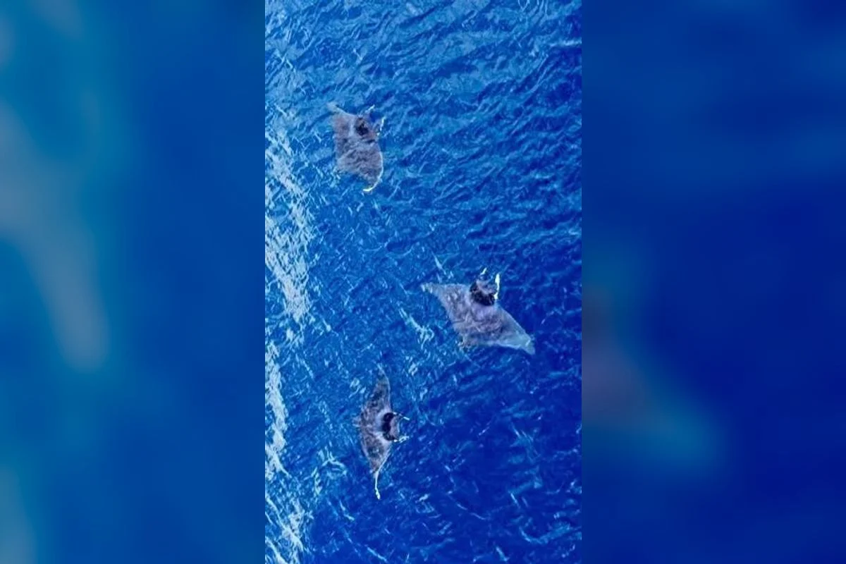 Spinetail devil rays filmed from the air off San Diego in 2026. Video frame: Big Blue Photo Expeditions.
What a Kelvin wave does to the California coast
A coastal-trapped Kelvin wave is a bulge of warm water that travels along the eastern edge of the Pacific at roughly 6 miles per hour, according to Weather.com. In El Niño years, the trade winds that normally hold the tropical warm pool against Asia slacken, warm water sloshes east against South America, and the excess propagates north along the shelf, deepening the thermocline, the boundary between warm surface water and colder water below, and lifting the sea surface as it passes.
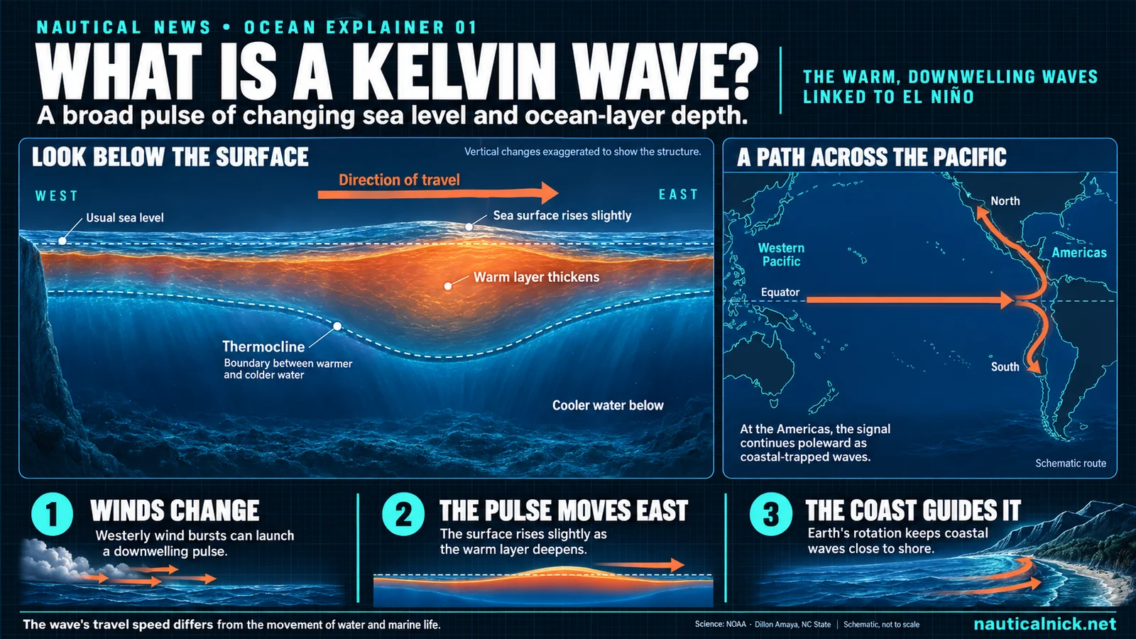 A Kelvin wave in cross-section and in plan view. Vertical changes are exaggerated. Nautical News explainer.
Dillon Amaya, an assistant professor of marine science at North Carolina State University, quoted by ABC7 News, described the incoming pulse as "a bulging of the nearest 20 to 30 kilometers of the ocean." Inside the wave, sea level is running 4 to 8 inches above normal and water off Baja has measured in the mid-80s Fahrenheit, according to the Sacramento Bee. Bay Area water levels are already running about 6 inches above normal, and the arriving wave is expected to add another 6 to 12 inches on top of that, per ABC7. As many as 3 or 4 additional waves may follow through fall and winter, and Bay Area sea level is not expected to return to typical conditions until spring 2027.
The stack matters most on days the ocean would already be high. California's next round of king tides, the highest astronomical high tides of the year, falls on November 24 to 26, 2026, according to the California Coastal Commission's King Tides Project. A Kelvin-wave foot layered onto a king tide, and layered again onto storm surf or an incoming winter swell, is the combination the proclamation names when it lists elevated baseline water levels, high tides, large waves, and coastal storms as the ingredients for coastal flooding and beach and bluff erosion. For divers and snorkelers, the same setup narrows the beach and stirs sand into the nearshore water on the biggest days.
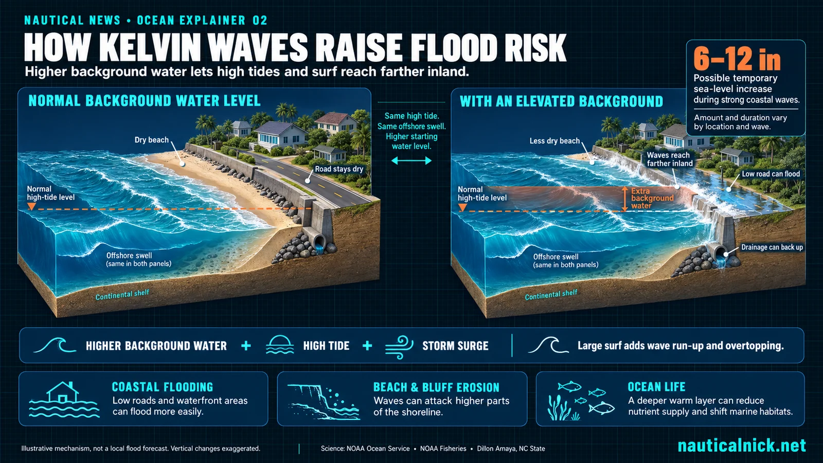 Same tide, same swell, higher starting water level. A raised background lets high tides and surf reach farther inland. Illustrative, not a local flood forecast. Nautical News explainer.
An active south-swell fall
El Niño years also tend to load the eastern Pacific hurricane basin, and the 2026 season is forecast well above average. NOAA's Climate Prediction Center outlook calls for 15 to 22 named storms, 9 to 14 hurricanes, and 5 to 9 major hurricanes off the Pacific coast of Mexico, compared with long-term averages of about 8 hurricanes and 4 majors per season. The outlook set a 70 percent chance of an above-normal season, according to NOAA.
Named storms tracking off Baja and mainland Mexico generate the south and southwest swells that reach Southern California through the fall, most memorably in September and October. A more active basin means more of them, often stacked closer together, and often on top of already elevated seas from the Kelvin wave.
Why the stack could turn catastrophic
Three separate things are due to arrive on the Southern California coast at the same time this fall, and none of them is dangerous alone.
The first is the Kelvin wave, worth 6 to 12 inches of extra sea level for weeks at a stretch. The second is the tide. NOAA's predictions for the San Diego tide gauge put the late-October full moon high tide at 7.1 feet above the lowest normal low water on the morning of October 27, and that moon counts as a supermoon, a full moon near its closest approach to Earth, under the looser definitions in use, according to BBC Sky at Night Magazine. The official king tides run higher still: 7.4 feet on November 24 to 26 and 7.6 feet on December 23 to 25, the highest water of the year at that gauge. Add the Kelvin wave to the October tide and the water stands at roughly 7.6 to 8.1 feet before a single wave breaks, a sum that is illustrative rather than a forecast, since the wave's height on any given day is not known in advance. The third is swell. An above-average hurricane season off Mexico means more long-period south swell arriving through October, and later in the season the first winter storms bring surf from the northwest on top of whatever the tide and the wave have already done.
The proclamation names this combination in its own words. Elevated baseline water levels, combined with high tides, large waves, high surf, and coastal storms, "can increase risks of coastal flooding, beach erosion, bluff erosion, transportation disruption, and damage to public and private infrastructure," it reads. Low-lying coastal development along this coast, the beachfront streets, parking lots, harbor edges, and bluff-top roads, was built to the tide range of the last century, with no margin for an extra foot of ocean under a 7-foot tide. That is where a high tide stops being a spectacle and becomes catastrophic flooding.
The record shows what it looks like. On February 3, 1998, during the last El Niño of this size, the early-morning high tide at Fort Point beside the Golden Gate Bridge measured 5 feet above mean sea level, about 2 feet higher than expected, according to a U.S. Geological Survey fact sheet on that winter. The Pacific surged over parking lots and the coastal highway at Ocean Beach, whitecaps up to 6 feet high broke over the Embarcadero, U.S. Highway 101 north of the bridge went under as much as 4 feet of bay water, and hundreds of people fled their homes around the bay. The USGS put the flood and storm damage in the Bay Area alone at hundreds of millions of dollars. The same winter killed 17 people statewide.
What 1997-98 and 2015-16 looked like
The last two events at this scale were the 1997-98 El Niño and the 2015-16 event. In January 2016, NOAA's Oceanic Niño Index put the 2015-16 event at 2.3 degrees Celsius above average for October through December, level with the 1997-98 peak, according to The Weather Channel's reporting at the time. February 1998 brought 4 weeks of nearly continuous storms to California, with damage then estimated at more than 550 million dollars and expected to climb, and the state reported 17 storm deaths for the winter, according to a NOAA National Climatic Data Center report on that season. Santa Barbara recorded 21.74 inches of rain that month, a record for any month there since 1867.
The season the state is bracing for
Newsom's order runs against that history. The proclamation is on the books before the first atmospheric river of the season. The water is on the way regardless. The first sign of it, a bulge of warm sea running up the shelf, will register on the tide gauge at Scripps Pier in La Jolla before any storm does.
Sources
- Office of Governor Gavin Newsom, "Governor Newsom Proclaims State of Emergency to Bolster Statewide El Niño Preparedness, Protect California," September 21, 2026, https://www.gov.ca.gov/2026/09/21/governor-newsom-proclaims-state-of-emergency-to-bolster-statewide-el-nino-preparedness-protect-california/
- Office of Governor Gavin Newsom, Proclamation of a State of Emergency (signed text), September 21, 2026, https://www.gov.ca.gov/wp-content/uploads/2026/09/SIGNED_Super-El-Nino-SOE-9-21-26.pdf
- KTLA, "State of emergency declared for all of California ahead of strong El Niño forecast," September 21, 2026, https://ktla.com/news/california/state-of-emergency-declared-for-all-of-california-ahead-of-strong-el-nino-forecast/
- Weather.com, "State of emergency declared for California ahead of potentially historic El Niño," September 21, 2026, https://weather.com/2026/09/21/news/state-of-emergency-declared-for-california-ahead-potentially-historic-el-nino
- NOAA Climate Prediction Center, "ENSO Diagnostic Discussion," September 10, 2026, https://www.cpc.ncep.noaa.gov/products/analysis_monitoring/enso_advisory/ensodisc.shtml
- Sacramento Bee, Nathaniel Levine, "El Niño-born 'Kelvin waves' are sneaking towards California. What to know," September 2026, https://www.sacbee.com/
- Los Angeles Times, Rong-Gong Lin II, on the Kelvin wave's expected arrival in Southern California, September 10, 2026, https://www.latimes.com/
- ABC7 News, "El Niño-driven Kelvin wave could raise Bay Area sea levels 1 foot in October, scientists say," September 18, 2026, https://abc7news.com/post/el-nio-driven-kelvin-wave-could-raise-bay-area-sea-levels-1-foot-october-scientists-say/19841795/
- Weather.com, "El Niño Kelvin wave could raise California sea levels this winter," September 12, 2026, https://weather.com/2026/09/12/safety/floods/el-nino-kelvin-wave-california-sea-levels-flooding-winter-fall
- Fox Weather, "El Niño continues to strengthen, now 75 percent chance of becoming strongest in history," September 2026, https://www.foxweather.com/weather-news/el-nino-continues-strengthen-now-75-chance-becoming-strongest-history
- EarthSky, "Super El Niño may drive record temperatures in 2026-2027," 2026, https://earthsky.org/earth/super-el-nino-record-temperatures-2026-2027/
- NOAA Climate Prediction Center, "2026 Eastern Pacific Hurricane Season Outlook," 2026, https://www.cpc.ncep.noaa.gov/products/Epac_hurr/
- Los Angeles Times, Corinne Purtill, "Sea turtle laying eggs at Huntington Beach is first known instance of nesting on West Coast," September 22, 2026, via The Spokesman-Review, https://www.spokesman.com/stories/2026/sep/22/sea-turtle-laying-eggs-at-huntington-beach-is-firs/
- ABC7 Los Angeles, "Olive ridley sea turtle lays eggs in Orange County. It's a first for the West Coast," September 22, 2026, https://abc7.com/post/olive-ridley-sea-turtle-lays-eggs-orange-county-first-west-coast/19856119/
- For The Win, Pete Thomas, "Free-jumping marlin grabs spotlight during wildly exotic SoCal season," September 22, 2026, https://www.yahoo.com/lifestyle/articles/free-jumping-marlin-grabs-spotlight-160951991.html
- For The Win, Pete Thomas, "Massive blue marlin caught off San Diego dubbed 'El Niño fish'," September 20, 2026, https://www.yahoo.com/lifestyle/articles/massive-blue-marlin-caught-off-205730966.html
- Catalina Island Marine Institute, "Spotting Sea Turtles Around Catalina," https://www.cimikelp.org/news/spotting-sea-turtles-around-catalina-how-to-help-identify-our-local-visitors
- NOAA Tides and Currents, tide predictions for San Diego, station 9410170, October to December 2026, https://tidesandcurrents.noaa.gov/noaatidepredictions.html?id=9410170
- U.S. Geological Survey, "El Niño Sea-Level Rise Wreaks Havoc in California's San Francisco Bay Region," Fact Sheet 175-99, https://pubs.usgs.gov/fs/1999/fs175-99/
- BBC Sky at Night Magazine, "We'll get three supermoons in 2026," https://www.skyatnightmagazine.com/advice/supermoons-2026
- California Coastal Commission, "California King Tides Project," 2026, https://www.coastal.ca.gov/kingtides/
- The Weather Channel, "Current El Niño Ties 1997-1998 as Strongest on Record, Says NOAA," January 2016, https://weather.com/news/climate/news/el-nino-ties-record-january-2016
- NOAA National Climatic Data Center, "The El Niño Winter of '97-'98," Technical Report 98-02, https://www.ncei.noaa.gov/monitoring-content/billions/reports/19971201-19980228-severe-storm/tr9802.pdf